Santa Ana Volcano stands 2,381 meters above sea level in western El Salvador, making it the country's highest peak. Hikers climb 4.3 miles through cloud forest to reach a steaming, 60-degree Celsius turquoise crater lake at the summit.
Santa Ana Volcano dominates the western skyline of El Salvador at 2,381 meters above sea level. This active stratovolcano sits immediately west of the Coatepeque Caldera within the Central America Volcanic Arc. Hikers tackle a 4.3-mile out-and-back trail starting from Cerro Verde National Park to reach the summit. The ascent takes roughly two hours. The trail begins under a dense jungle canopy that provides essential shade from the tropical heat. You hear the rustle of undergrowth and might spot local wildlife like armadillos, lizards, or endemic bird species darting between the branches. The humidity traps the heat, making the first hour of the climb physically demanding despite the moderate incline.
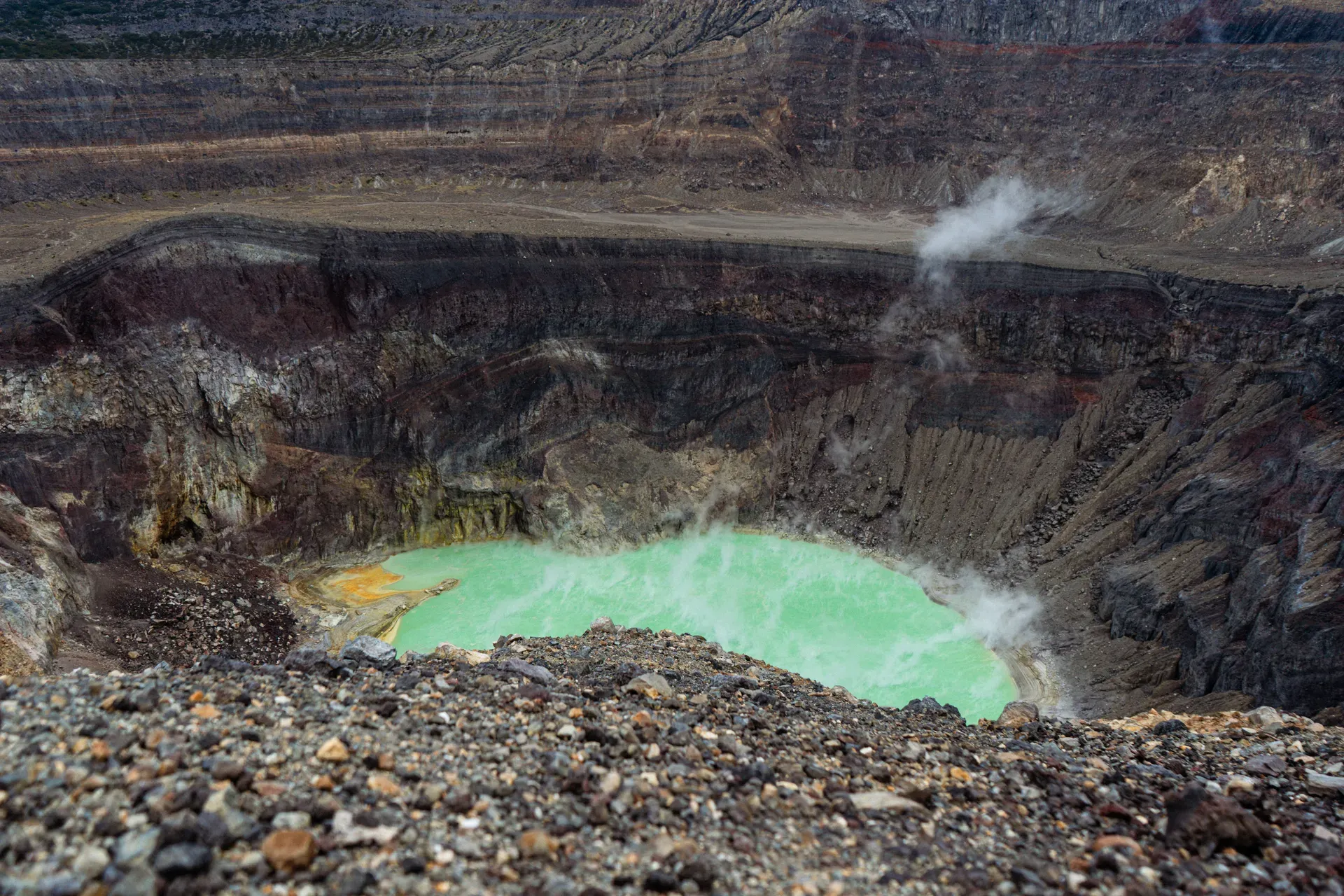
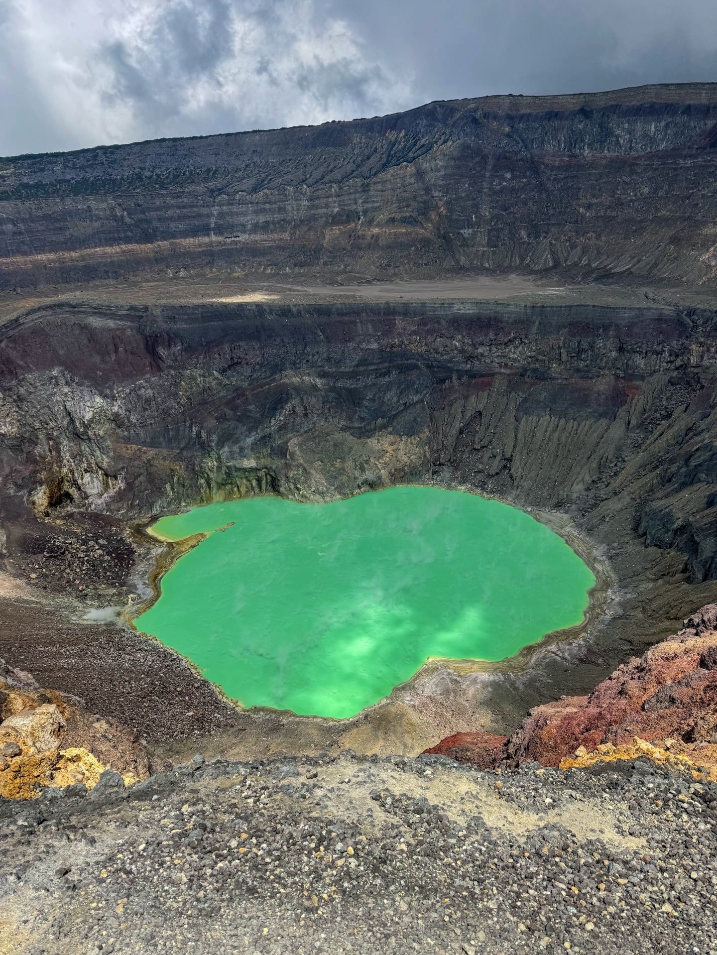
The upper slopes transition abruptly into a barren landscape of loose volcanic gravel and hardened lava. Strong wind gusts hit hikers as they approach the exposed crater rim. Looking down into the caldera reveals a steaming lagoon filled with opaque turquoise-green water. High concentrations of sulfur create this intense color, while volcanic vents heat the liquid to temperatures between 45 and 60 degrees Celsius. Steam hisses continuously from yellow-stained rocks along the water's edge. The smell of sulfur hangs heavy in the air, reminding climbers that the mountain remains highly active. Visitors get exactly 30 minutes at the top to take photographs before guides initiate the descent. The descent takes about an hour and a half, requiring careful foot placement to avoid sliding on the loose rocks.
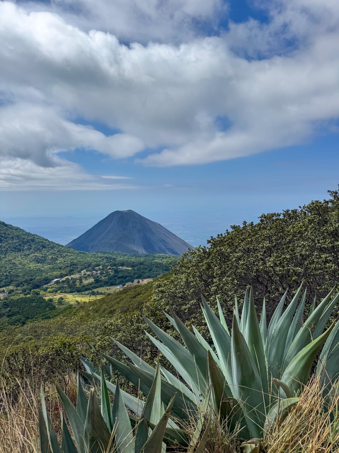
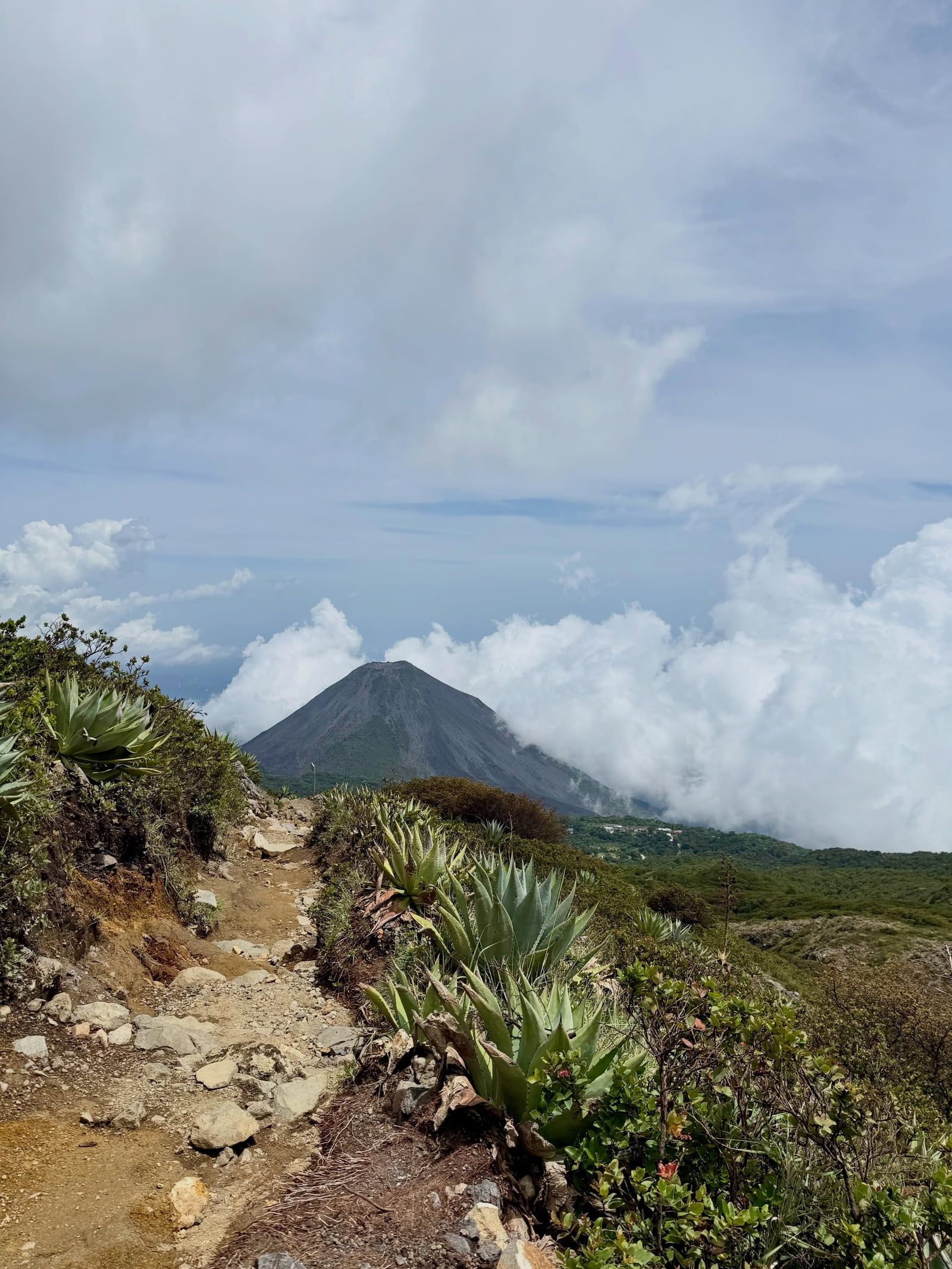
Weather dictates the entire experience. Park rangers cancel the mandatory 11:00 AM guided hikes during heavy rain or lightning storms. July through November brings dense fog that frequently swallows the peak, blocking all visibility. Hikers who visit between December and April find clear skies and direct sightlines to the neighboring Izalco Volcano and the shimmering blue expanse of Lake Coatepeque far below. The dark, barren slopes of Izalco provide a sharp visual contrast to the surrounding green forests.
Logistics require careful timing. The only guaranteed public transport from Santa Ana city, the #248 bus, departs strictly between 7:30 AM and 7:40 AM from the Sala de Espera y Abordaje on 11 Calle Pte. Missing this ride means missing the 11:00 AM group departure at the trailhead. Bring exact change for the $6.00 foreigner entrance fee, the $3.00 park entry, and the $1.00 guide tip.
A massive late Pleistocene collapse shaped the early geological footprint of Santa Ana Volcano. The mountain's flank gave way under immense pressure, producing a voluminous debris avalanche that swept toward the Pacific Ocean. This catastrophic event formed the Acajutla Peninsula, permanently altering the coastline of western El Salvador. The volcano subsequently rebuilt itself through countless eruptions over millennia, establishing a broad andesitic-to-basaltic cone. Layers of ash and lava hardened into the massive structure that currently towers over the Santa Ana department.
Spanish colonizers first documented eruptions here in 1520. Two centuries later, a major event reshaped the eastern slopes. In 1722, the San Marcelino cinder cone erupted violently, sending a river of lava 13 kilometers to the east. This eruption destroyed local vegetation, displaced indigenous communities, and left behind jagged basalt fields that still define the lower terrain today. The volcano continued to vent gas and ash periodically throughout the 19th and 20th centuries. These frequent minor eruptions maintained its status as a constant, underlying threat to the growing populations in the surrounding valleys.
Late 2005 brought the most recent deadly eruption. On October 1, without significant warning, the volcano expelled a massive column of ash 10 kilometers into the sky and launched car-sized rocks into the surrounding coffee plantations. Boiling water from the crater lake spilled over the rim, triggering scalding mudslides that swept down the slopes. Two people died during the explosion, forcing thousands to evacuate the immediate area. Ash coated nearby towns, destroying crops and contaminating local water supplies for months. The eruption forced the temporary closure of the national park while authorities assessed the structural integrity of the crater rim.
Today, seismologists closely monitor the 20-kilometer-long fissure system extending along its flanks. Sensors track ground deformation and gas emissions to predict future activity. Visitors walking the crater rim must stay behind simple rope boundaries, as the loose, steep edges offer no guardrails against a fall into the acidic lake below. The mountain remains a volatile giant, capable of waking up at any moment. Park rangers enforce strict speed limits of 10 kilometers per hour in the Los Andes sector to ensure safe evacuation routes remain clear.
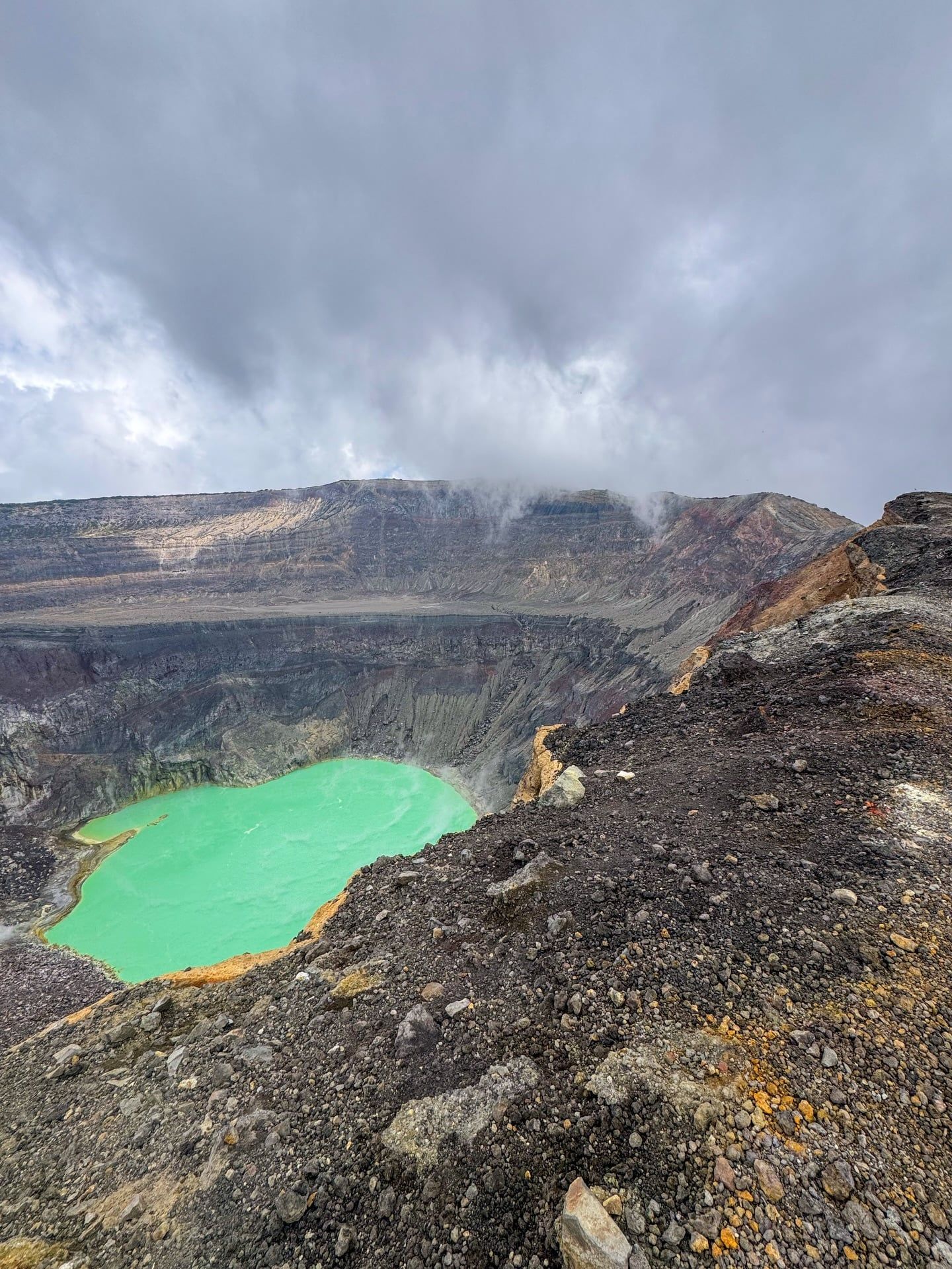
Four nested crescentic craters form the broad summit of Santa Ana. The outermost rim stretches 3.5 kilometers in circumference, dropping steeply into a central depression. Inside this deepest crater sits the active acid lake. The water consists of 90 percent sulfur and 10 percent trace minerals, resulting in a distinct, opaque turquoise color. Temperatures fluctuate between 45 and 60 degrees Celsius. Visitors standing at the edge can hear the water boiling and watch steam rise from active fumaroles along the inner walls. Yellow sulfur deposits stain the dark gray igneous rocks surrounding the water, creating a stark color contrast against the barren crater walls.
A 20-kilometer-long fissure system cuts across the volcano's flanks. This structural weakness allows magma and gases to travel toward the surface, feeding the constant hydrothermal activity at the peak. The upper slopes consist entirely of igneous rock, hardened lava flows, and loose scoria. Hikers navigate this terrain on a steep, narrow trail covered in slippery volcanic gravel. The first section of the trail includes wooden forest stairs built into the dirt path, making the initial climb manageable before the terrain turns hostile. Trekking poles provide essential stability during the descent, especially when strong winds batter the exposed ridges. There are no trees to break the wind or block the intense equatorial sun on the final push to the summit. The air grows noticeably thinner at 2,381 meters, forcing many climbers to stop and catch their breath.
The lower elevations support a highly specialized ecosystem within Cerro Verde National Park. The mineral-dense volcanic soil nourishes twelve endangered flora species and fifty-eight threatened plant varieties. Twelve endemic bird species inhabit the cloud forest canopy that covers the base of the mountain. The transition from lush jungle to barren rock happens rapidly, giving scientists a clear view of how altitude and volcanic soil composition affect plant growth. Thick mosses and bromeliads cling to the trees in the lower sections, thriving on the moisture trapped by the mountain's massive bulk. Drones are strictly prohibited throughout the park, ensuring the wildlife remains undisturbed and airspace above the active crater stays clear.
Indigenous communities call the mountain Ilamatepec, which translates to "hill of the old woman" in the native Nahuat language. This name roots the volcano deeply in pre-Columbian mythology, where towering peaks represented powerful deities and ancestral spirits watching over the valleys. The mountain dictated agricultural cycles, as its mineral-dense volcanic ash fertilized the surrounding soil. This natural fertilization enabled generations of farmers to cultivate the region's famous coffee crops, which remain a cornerstone of the local economy. Over 1.2 million people currently live within a 30-kilometer radius of the peak, their livelihoods directly tied to the soil the volcano produces.
The volcano's distinctive shape left a permanent mark on global literature. French author Antoine de Saint-Exupéry lived in El Salvador in the 1930s with his Salvadoran wife, Consuelo Suncín. The steaming craters of Santa Ana and its neighboring peaks directly inspired the active volcanoes featured in his famous novella, The Little Prince. The protagonist famously cleans his volcanoes to prevent them from erupting, a daily chore mirroring the constant vigilance required by those living in the shadow of Ilamatepec. The rose in the story is widely believed to represent Consuelo, tying the landscape of El Salvador directly to one of the world's most translated books.
Today, the summit serves as an unconventional marketplace. Local vendors hike the 4.3-mile trail carrying coolers full of fresh fruit popsicles and ice cream. They wait at the windy, 2,381-meter peak to sell cold treats to exhausted climbers. Buying a $1 popsicle while standing beside a boiling sulfur lake provides a stark contrast between local entrepreneurial grit and raw geological power. POLITUR (tourist police) officers accompany the daily hikes, a modern addition that ensures visitor safety and provides employment for local security personnel. Visitors must pack out all trash in plastic bags, as littering threatens the fragile ecosystem that supports these local businesses.
The 2005 eruption launched rocks the size of cars into nearby coffee plantations.
The turquoise crater lake is composed of 90 percent pure sulfur and 10 percent trace minerals.
The volcano inspired the active peaks in Antoine de Saint-Exupéry's famous novella, The Little Prince.
Local vendors regularly climb the 2,381-meter peak carrying coolers to sell popsicles at the crater rim.
An ancient collapse of the volcano's flank created El Salvador's Acajutla Peninsula.
The surrounding cloud forest provides a protected habitat for 12 endemic bird species.
Only one public bus, the #248, travels from Santa Ana to the trailhead each morning.
The volcano stands at 2,381 meters (7,812 feet) above sea level. This makes it the highest volcano in El Salvador.
The last major eruption occurred in late 2005. The explosion ejected massive rocks, triggered mudslides, and killed two people.
The turquoise water ranges from 45 to 60 degrees Celsius (113 to 140 degrees Fahrenheit). Active vents continuously heat the sulfur-rich liquid.
Yes, local laws require all visitors to hike with an authorized guide or a tourist police officer. Group hikes depart daily at 11:00 AM from the Cerro Verde ranger station.
The 4.3-mile out-and-back trail takes roughly 3 to 4.5 hours. This includes two hours to ascend, 30 minutes at the crater rim, and an hour to descend.
No, park authorities strictly prohibit drones at the summit and throughout Cerro Verde National Park. You must obtain a special permit in advance to fly one.
Wear sturdy hiking boots or sneakers with excellent traction to handle the slippery volcanic gravel. Bring a windbreaker, as the exposed summit experiences high winds and cold temperatures.
The intense green-blue color comes from a high concentration of dissolved minerals. The water consists of 90 percent sulfur and 10 percent other trace elements.
Foreigners pay a $6.00 volcano fee, a $3.00 park entry fee, and a $1.00 to $3.00 guide fee. Bring small bills and exact change to speed up the registration process.
Rangers frequently cancel hikes during heavy rain, dense fog, or lightning storms. The steep igneous rocks become dangerously slippery when wet.
Browse verified tours with free cancellation and instant confirmation.
Find Tours